
Transportation In the Park
For an individual to move around with reasonable speed and efficiency there are two main forms of transportation available depending on the season: in the Spring, Summer, and Fall cars and other road legal vehicles are widely used. In the winter the snowmobile emerges as both a way to bring in tourists and as a way to travel quickly across the park as roads become slippery and snow covered. ATV use is widely banned on public land in the park so, despite its prevalence, it lacks the legitimacy and the speed of these other two uses.
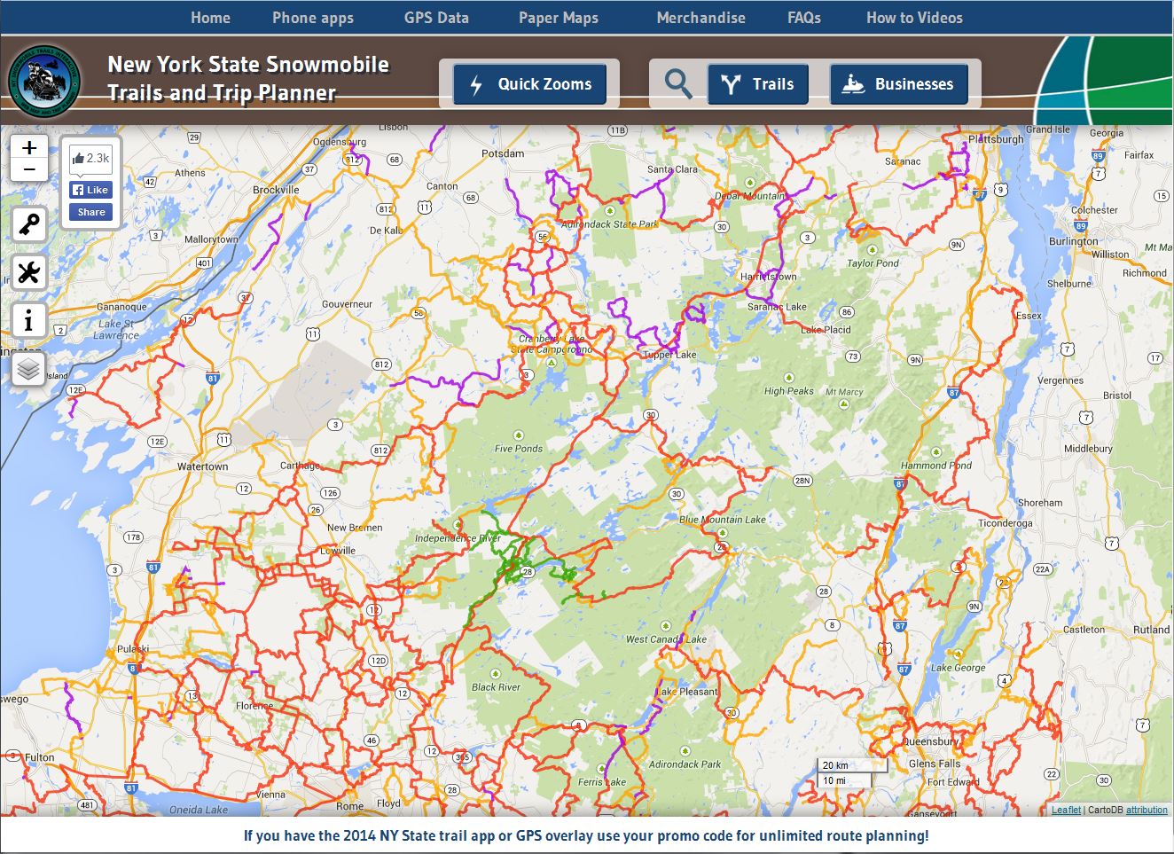

Map on the left shows snowmobile trails in the Adirondacks. As snowmobiles are not allowed on wilderness areas this limits the available trail mileage. Map from New York State Snowmobile Association, Google Maps, Leaflet, and CartoDB (http://nysnowmobilewebmap.com/webmap/index.php). Map on the right shows the trails and roads around the lower section of the Corridor. Map from APA (Image is a link).
These two maps show that the Corridor is an essential snowmobile link in the park as it is one of the few trails accross the park.
Public transportation in the Adirondacks
Though private automobile travel in the park is extremely prevalent and probably the most convenient option, trains (Amtrak) and buses (Adirondack Trailways and Greyhound Bus) do provide access to some towns in the Park.
Amtrak's Adirondack route runs year-round from New York City to Montreal. The north-bound train departs from New York City in the morning and arrives in Montreal at night. The Adirondack serves the following stations: Penn Station (New York City), Yonkers, Croton-on-Hudson, Poughkeepsie, Rhinecliff, Hudson, Rennselaer (Albany), Schenectady, Saratoga Springs, Fort Edward (Glens Falls), Whitehall, Ticonderoga, Port Henry, Westport, Port Kent, Plattsburgh, Rouses Point, St-Lambert (Quebec), Montreal (Quebec). A timetable and map can be found in the Amtrak Adirondack schedule guide. So, while Amtrack's Adirondack route serves several Adirondack towns, it does not connect Utica and Lake Placid, as a fully operational railroad along the corridor would. Also, since the train only runs once per day, traveling by train is still inconvenient in the Adirondacks.

This map is from trailwaysny.com. It shows the route of Adirondack - Pine Hil - New York Trailways. (Image is a link.)
Another transportation option, the Trailways bus company, has an Adirondack - Pine Hill - New York route. It runs east and west through Rochester, Syracuse, Utica, Gloversville, Amsterdam, Schenectady, and Albany. From Syracuse, the line runs north/south through Pulaski, Watertown, Gouverneur, DeKalb Jct, Canton, Potsdam, and Massena, there turning to continue south/north through Malone, Saranac Lake, Lake Placid, Keene Valley, Schroon Lake, Pottersville, Chestertown, Warrensburth, Lake George, Glen Falls, Saratoga, Malta, Clifton Park, and Albany. From Glens Falls, another line continues north to Plattsburgh, La Colle Border, Champlain, Longueuil, and Montreal. Thus, the Adirondack Trailways buses essentially serve a loop of towns along the perifery of the Park and also extend north to Canada (like Amtrak). The Remsen-Lake Placid Travel Corridor, on the other hand, crosses through the Park.
In the Adirondacks, the Greyhound Bus serves Glens Falls, Lake George, Warrensburg, Lake Placid, and Saranac Lake. A bus travels daily from Utica to Lake Placid, departing at 11:15 am and arriving at 5:45 pm. The ride costs $60.07. Clearly, the Greyhound's serves Adirondack towns less widely than the Amtrak and Adirondack Trailways.