

Regardless of the type of outdoor adventure, trails plays a major role in the success and organization of the recreational activity. In theory, a trail is a logical idea for environmentalism and tourism alike. Environmentally speaking, hiking trails concentrate erosion and any necessary deforestation to smaller areas, while for tourism, having a path to follow prevents hikers from losing their way. For similar reasons, having designated canoeing areas and trails is beneficial to the Adirondacks. One example of an Adirondack canoeing trail is the 740-mile-long Northern Forest Canoe Trail, which begins in Northern Canada and weaves through New Hampshire, Vermont, and finally through the Adirondacks (Pollock et. al.-UVM: Abstract). Writer Paul Schneider advocates for other additional benefits of a canoeing trail, stating that parts of the trail are, “equipped with guides and outfitters capable of supplying travelers with as much or as little as they may need in the way of boats, equipment, food or even instruction, making it relatively simple to put together a comfortable voyage” (Schneider: NYT 2006). As Schneider explains, and as he personally experienced, canoeing on this predetermined path provided him with certain advantages for both tourists and the park at large. Encouraging tourists to use only specific areas can, in turn, be mutually beneficial.

Petersent/Wikimedia
Aside from the Northern Forest Canoe Trail, there is also a designated canoe area within the Adirondacks. The St. Regis Canoe Area is located in the northern region of the Adirondacks and encompasses 18,400 acres, including 59 bodies of water for paddling (NYS DEC: St. Regis Canoe Area). The New York State Department of Environmental Conservation (DEC) published a guide, that details how visitors can get the most out of the park, while keeping the protected wilderness in the best possible condition. One such way that the DEC instructs paddlers to remain on designated campsites to prevent deforestation. Within the St. Regis Canoe Area, the DEC has cleared 75 campsites, strategically located along the water for the use of paddlers (NYS DEC: St. Regis Canoe Area). Having specific campsites prevents paddlers from needing to clear lands for an evening, and additionally, allows park rangers to keep track of the people in the canoeing areas, as they are confined to preexisting, well marked, locations.
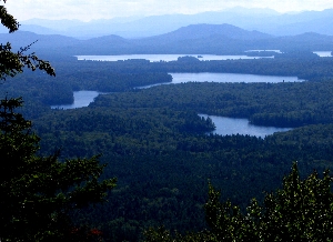
Mwanner/Wikimedia
_______________________________________________________________________________________________________
Works Cited:
1. Pollock, Noah, Lisa C. Chase, Clare Ginger, and Jane Kolodinsky. The Northern Forest Canoe Trail: Economic Impacts and Implications for Sustainable Community Development. Rep. Burlington, VT: U of Vermont, 2007. Print. PDF used from www.nps.gov
2. Schneider, Paul. "The Magnificent Obsession of the Northern Forest Canoe Trail." The New York Times. The New York Times, 10 Sept. 2006. Web. 21 Feb. 2015.
3. "St. Regis Canoe Area." Forest Preserve Unit Descriptions - St. Regis Canoe Area. New York State Department of Environmental Conservation, n.d. Web. 24 Feb. 2015.
4. Johnstone, Meghan, Eric Holmlund, Hilary Smith, Meg Modley, Emily DeBolt, and Kristen Rohne. Boat Inspection and Decontamination for Aquatic Invasive Species Prevention-Recommendations for the Adirondack Region. Rep. N.p.: n.p., 2014. Adirondack Park Invasive Plant Program, Paul Smith's College, Lake Champlain Basin Program, Lake George Association. Web. 22 Feb. 2015.
Photos:
1. (Petersent/Wikimedia) http://commons.wikimedia.org/wiki/File:Northern_Forest_Canoe_Trail_sign_in_Enosburg_Falls.JPG
2. Mwanner at en.wikipedia [GFDL (www.gnu.org/copyleft/fdl.html) or CC-BY-SA-3.0 (http://creativecommons.org/licenses/by-sa/3.0/)], via Wikimedia Commons ([Picture of St. Regis Canoe area] (http://commons.wikimedia.org/wiki/File:Long_Pond_Mtn_View.jpg))